

Big Bend Wall Opponents Ask Congress To Block Funds
U.S. Customs and Border Protection recently posted a map charting a major expansion of the border wall — right through one of America’s most iconic wild areas.

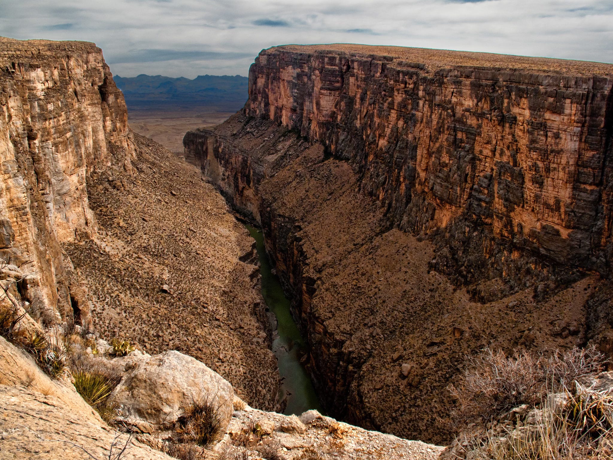
In a map update posted last month to U.S. Custom and Border Protection’s website, the agency charted a major expansion of the border wall. It included terrain belonging to one of America’s most iconic wild areas, Big Bend National Park, an 800,000-acre desert landscape that includes the entire Chisos mountain range and more than 100 miles of the Rio Grande.
A few steeply cliffed sections, including the famed Santa Elena Canyon, were marked “detection technology.” The rest of the park’s southern border, which touches Mexico, was designated “primary wall border system.”
Click here to download the map file, which was saved by the Center for Biological Diversity and shared with Public Domain.
CBP’s map, which appeared to call for a towering wall across a beloved national park, elicited fury from local politicians, law enforcement officials and conservationists across the country. CBP has since quietly altered its map, with an updated version limited solely to “detection technology” within the national park — though the proposal still appears to call for a physical wall within neighboring Big Bend Ranch State Park.
Opponents of a Big Bend border wall have welcomed CBP’s map tinkering as evidence that the public outcry has forced the agency to back down. But Homeland Security, CBP’s parent agency, has said little to re-assure conservationists.
Public land defenders are now instead urging Congress to step in. A group of more than 100 conservation groups and local businesses signed on to a letter Thursday asking the federal lawmakers currently wrangling over the DHS budget to block the agency from using its $46.5 billion border wall budget from building physical barriers, roads or lighting through the two parks.
“Building a border wall through one of the nation’s crown-jewel national parks and Texas’ largest state park would be wholly unprecedented, and the resulting damage to public recreation, wildlife, rural economies, cultural resources, and the integrity of our natural heritage would be irreversible,” the letter reads.
The groups are hoping that shielding national treasures will cut through the partisanship that typically plagues Washington. Former Big Bend National Park Superintendent Bob Krumenaker is currently on Capitol Hill, meeting with environmental leaders and lawmakers.
“I have not found anyone that is saying they think a wall in the park, or even the state park, is a good idea,” said Krumenaker, who now heads the group Keep Big Bend Wild.
A Constantly Shifting Plan
Part of the reason Homeland Security’s Big Bend wall plans have drawn so much outrage is that the agency has done little to explain itself, even as big changes are clearly taking place.
Prior to her departure from the Department of Homeland Security on March 5, former Secretary Kristi Noem used her authority last month to waive a slew of environmental regulations to speed along construction of the border wall in the Big Bend sector. The sector stretches roughly 500 miles across southwest Texas. Shortly after her order, CBP made the controversial changes to the “smart wall” map on its website, with portions of the border wall proposed within the national park and the state park.
But the waiver that Noem signed applies only to a roughly 155-mile section bracketed by a pair of GPS coordinates that includes a portion of Big Bend Ranch State Park. It does not include land within Big Bend National Park, raising questions about whether the department has the legal authority to build there without abiding by the regulations mandated by major federal laws Noem waived, like the National Environmental Policy Act, the Endangered Species Act or the National Historic Preservation Act. DHS did not respond to a request for comment.
CBP’s only public statement on the issue so far is a pair of unsigned paragraphs issued late Friday saying that the border barrier project through the parks remains in its planning stages. The agency will “continue to coordinate with the National Park Service, Texas Parks and Wildlife Department and other federal and state agencies, throughout the planning of border barrier and technology deployments, in order to achieve Border Patrol’s operational priorities,” the statement said.
“Nobody has any confidence that they even know what they’re planning,” Krumenaker said. “We do know that contractors are on the ground.”
Many are also concerned that even detection technology may be too intrusive for protected public lands valued for their wildness. In Arizona, detection technology includes large towers that emit loud noises, said Laiken Jordahl, a public land advocate with the Center for Biological Diversity.
“We have no assurance they’re not going to completely destroy our landscape,” said Billy Bartko, whose Far-Flung Outfitters guides river and ATV trips at Big Bend. “One of my biggest concerns, whether it’s a physical wall or technology-only, is whether they’re going to light it up at night. If they light it up, our dark skies are gone. Our astro tourism is gone. Our birds. The lights in my opinion will be the most destructive of all.”
Local political and law enforcement officials from both parties have panned the wall proposal, partly because the sector sees so little illicit activity. The geography of the desert region, with its cliffs and mountains, makes it unattractive for jumping the border. Neither side of the border features large cities that draw people. The Mexican side is sparsely populated.
“Border security is not a one-size-fits-all proposition,” a group of five Big Bend border sheriffs wrote in a joint letter this week. “Strategies that may be appropriate in high-traffic urban sectors are not necessarily appropriate in geographically remote regions such as ours. Sound policy must be informed by local terrain, operational realities, and fiscal responsibility.”
Border Patrol has apprehended 734 people across the entire 500-mile long Big Bend sector since October — a figure that amounts to just 2 percent of apprehensions across the entire southern border. Within Big Bend National Park itself, Border Patrol made between 100 and 125 arrests annually in 2023 and 2024, according to data obtained by Krumenaker. Those numbers likely continued to drop since last year, following the Trump administration’s border crackdown.
CBP said it could not provide arrest data within the boundaries of Big Bend National Park.
But despite the fact that the Big Bend National Park sees relatively little immigration pressure, Trump’s border fixation incentivizes DHS to consider walling the park. Much of the existing wall in the west is built on federal public land. Texas is 95 percent privately held. Historic attempts to put up border wall in the state have repeatedly caused disputes with private land owners, slowing the process.
“If you’re just looking at a map and thinking, ‘what lands do we control, where we can build a wall because we want to say Trump built 200 miles of wall in his first year’ — that would be the place to look,” Jordahl said.
Thanks, Roque for great coverage!
If anyone reading this would like to support this fight, please see Keep Big Bend Wild’s page with what you can do and the talking points you can use:
https://keepbigbendwild.org/wp-content/uploads/2026/03/KBBW-Wall-Handout-2026-Mar-4.pdf
And please add your name to those who are willing to stand up in opposition:
https://keepbigbendwild.org/become-a-supporter/
Bob Krumenaker
Former BBNP Superintendent
Chair, Keep Big Bend Wild
Great piece Roqué