

Trump’s Border Wall Plans Threaten Texas Public Hunting Lands
Overshadowed by the fight over Big Bend, the White House’s wall expansion could degrade some of the few public hunting opportunities in Texas.

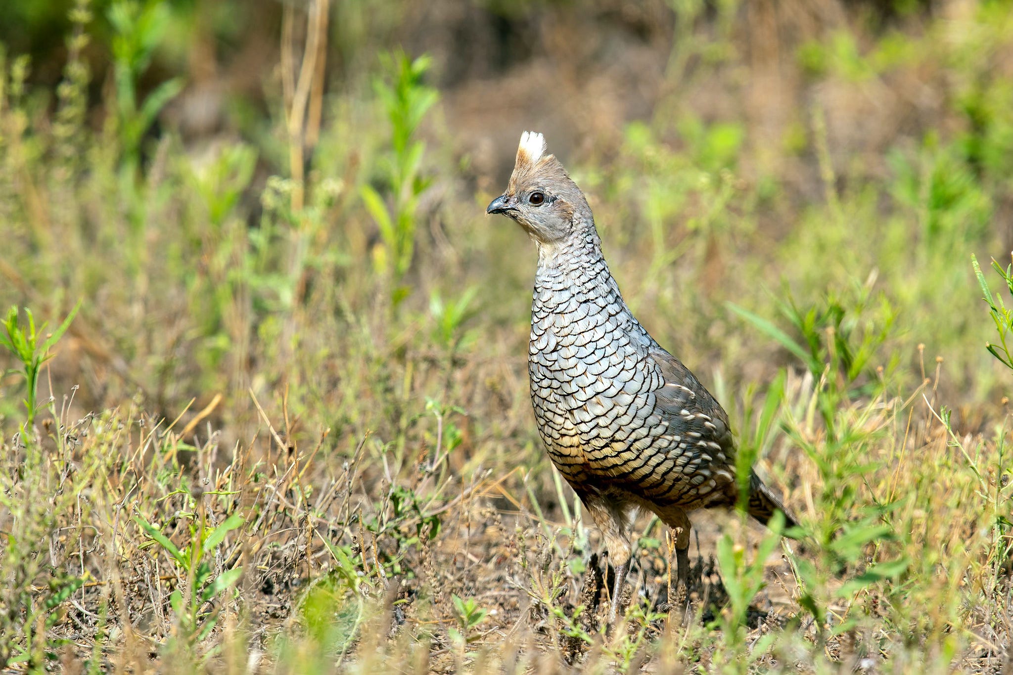
Toward the eastern edge of Big Bend National Park lies a stretch of Texas public land that sprawls across the rugged Chihuahuan desert. Black Gap Wildlife Management Area is home to bighorn sheep, black bears, mule deer and quail. At more than 100,000 acres, it is the state’s largest wildlife management area, or WMA. In a state that is 95 percent privately owned, it’s one of the most remote public parcels that hunters can freely roam in search of small game.
The Trump administration’s planned border wall threatens to cut right through it.
Since February, Customs and Border Protection has drawn furious backlash from the public over constantly shifting plans to expand its border wall infrastructure into two cherished west Texas wildlands — Big Bend National Park and neighboring Big Bend Ranch State Park.
But the wall expansion is also likely to impact several public parcels held by the state that have attracted less attention, including unique public hunting grounds in a state where pay-to-play access dominates. The Trump administration’s plans appear to impact two large walk-on properties, and several more that conduct a limited number of coveted big game hunts by lottery.
“We have some great public hunting opportunities in Texas, but it’s limited and hard to come by,” Texas Backcountry Hunters and Anglers Policy Chair Jake Walker wrote in an email. “Losing these areas would be a huge step back for sportsmen and women looking for that rugged sense of adventure you typically have to leave the state to find.”
Texas Parks and Wildlife Department biologists were caught off-guard by the sweeping border wall expansion when CBP first contacted them to ask for access to state holdings for construction in January, according to communications that Public Domain obtained through an open records request.
Some Texas Parks and Wildlife officials appeared unaware that Congress had stuffed a walloping $46.5 billion into Trump’s “big, beautiful” spending bill last year to expand the border wall. Some staffers appeared to find out only after the superintendent for Kiewit Infrastructure Co. wrote to them on Jan. 15 to ask logistical questions about road building on state park land, “blasting and material for fence alignment,” and access to the Rio Grande for construction water usage.
Wall construction was slated to begin in August, the infrastructure company wrote in an email to TPWD.
“This came to my attention today,” TPWD’s state regional parks director for west Texas wrote to colleagues in a Jan. 15 email in reference to the infrastructure company’s queries. “We don’t have much if any background on what this entails but wanted to ensure that everyone was aware and see if others are read in. It appears from the message that some work may be imminent.”
“We were not aware,” the Texas State Parks natural resources program director responded. “This is quite the surprise.”
Most of the discussions between Texas and federal officials centered on Big Bend Ranch State Park, the Lone Star State’s largest park, at 300,000 acres.
Border Patrol official Paul Enriquez wrote to Texas Parks and Wildlife officials on March 6 to tell them that the Big Bend parks were both “currently low priorities for the Border Patrol.” The letter was first reported by Inside Climate News.
“Once all our border wall contracts are awarded and the higher-traffic areas are addressed, we will review our plans for these areas to evaluate operational requirements that dictate barrier, roads, and/or technology,” Enriquez wrote. “However, at this time, we are placing our construction efforts on hold adjacent to TPWD land and the Big Bend National Park.”
CBP also made clear, however, that it intends to push the wall expansion through several other state-held public lands. The agency said in a series of letters that it may attempt to use eminent domain to secure access to Texas-owned properties if the state won’t provide it.
TPWD did not respond to a request for comment for this article. In the past, the agency has referred Public Domain to CBP for questions about the wall expansion.
The planned wall expansion through Texas public hunting lands has raised concerns from conservationists about both hunter access and the health of wildlife populations. Roughly 14 miles of Black Gap WMA run along the bank of the Rio Grande. The river offers key habitat and water for wild ungulates, black bears, quail and other wildlife. But an interactive wall map posted to CBP’s website over the last few months showed that the agency has contemplated walling off river access — likely with 30-foot tall steel bollard fencing. CBP started reaching out to Texas Parks and Wildlife officials in February to discuss its intent to build border wall infrastructure there, the records show.
Such an imposing wall would block hunters from one of the most fertile grounds in the WMA. It also would disrupt river access and wildlife migration for the large mammals found in the region, including a state-threatened black bear population and desert bighorn sheep — a species the state has spent millions of dollars trying to restore.
Those trade-offs might be worth considering if the region presented security threats or unlawful migration problems, according to Texas Wildlife Association’s Chief Executive Officer Justin Dreibelbis. But the 500-mile border stretch that CBP classifies as the Big Bend sector, which includes Black Gap, has long seen low numbers of migrant apprehensions. The roughly 3,000 Border Patrol apprehensions in the Big Bend sector last year accounted for less than 2 percent of arrests on the southwest border.
“If there’s a need for it, I think it would be a good thing to show people what that need is based on — I just haven’t seen it,” Dreibelbis told Public Domain. “We just don’t think the Big Bend region is one of those high-traffic areas. The risk is far higher than the reward when we’re talking about some of these pristine landscapes and some of these affected species like bighorns.”
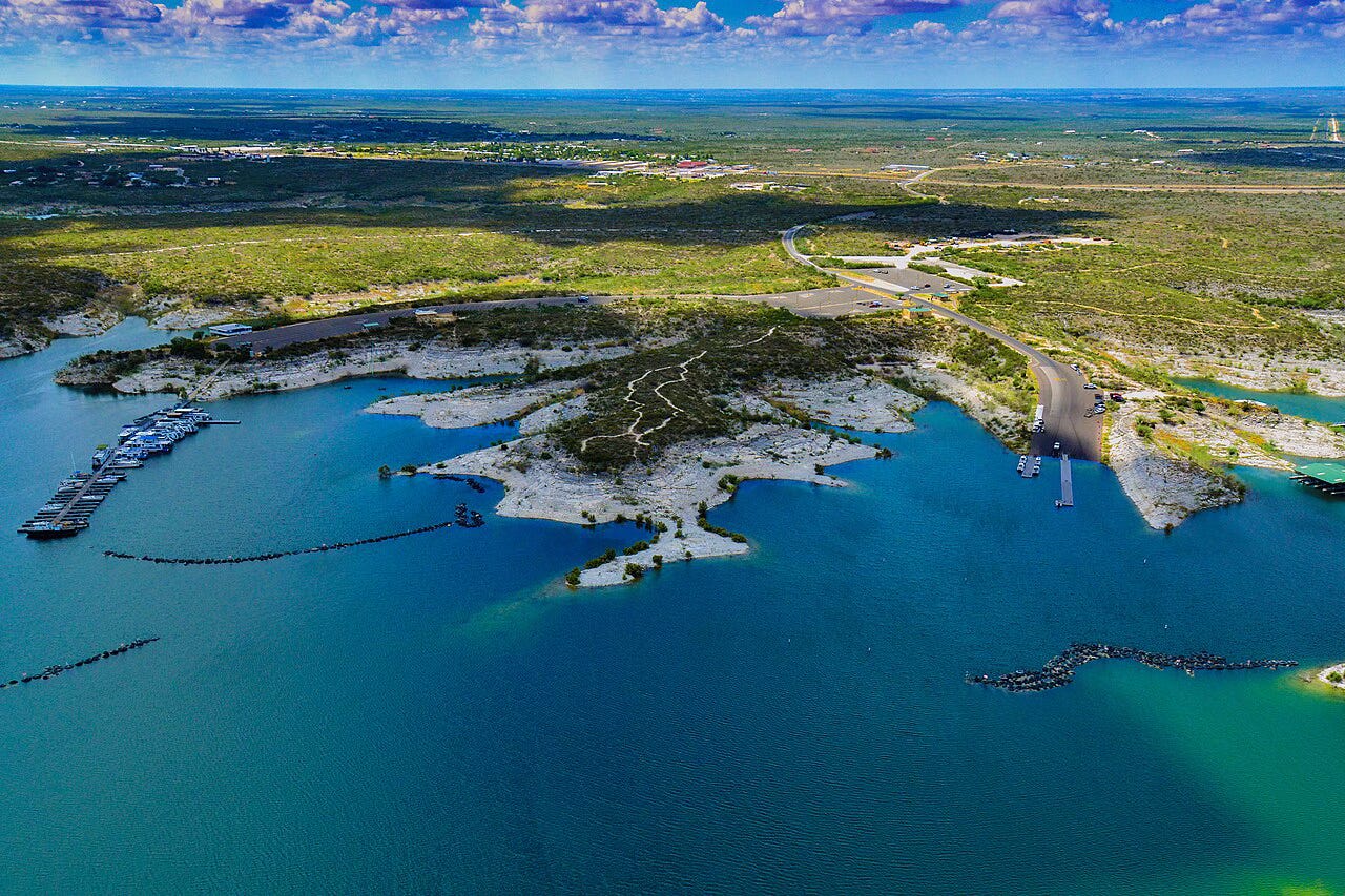
CBP also appears to be considering expanding the border wall through Lake Amistad National Recreation Area, a National Park Service property at the confluence of the Rio Grande and the Devil’s River.
Public hunting grounds account for less than 1 percent of Texas land. Because demand far exceeds supply, hunters can only access many of those properties by drawing a special permit that allows them to hunt for a few days.
Lake Amistad is the only public land property where Texas bowhunters can chase aoudad, an exotic sheep common in the state, without drawing a permit. The area also offers walk-on hunting access for whitetail deer, hogs and small game. CBP is considering wall plans in the area that would block access to large chunks of the hunting grounds at Lake Amistad, according to map files posted in recent months to CBP’s website.
“The first map we saw from DHS had [Lake Amistad NRA] public hunt area 1 completely behind the wall,” Walker, from Texas BHA, wrote. “That’s a third of the public hunting land in the whole park, and the hunting area with the most shoreline. The worst part is that the more this drags on, the less we seem to know about it.”
CBP’s plans have consistently confused and enraged environmentalists, public land users and even Texas elected officials. The agency quietly revised an interactive map of the border wall on its website in February, showing that it planned to erect large segments of “primary wall border system” in Big Bend National Park and Big Bend Ranch State Park.
Facing widespread opposition from the public and across the political spectrum, the agency appeared to backtrack, revising the map multiple times. Later iterations showed that CBP planned only “detection technology” in the two parks — an unclear term that can include everything from underground sensors to roving, lighted towers.
Publicly, CBP has only said that it is weighing its options and talking with local stakeholders. The agency removed the interactive map from its website this month.
The Friends of the Ruidosa Church, river guide Billy Miller and the Center for Biological Diversity sued the Department of Homeland Security last week, alleging that DHS violated federal law by hastily waiving a slew of environmental and historic preservation laws in February in order to fast-track border wall construction in the Big Bend region.
“The Department of Homeland Security has unconstitutionally gutted our nation’s bedrock environmental laws to build a wildlife-killing wall that would permanently lock away the Rio Grande,” a public land advocate with the Center for Biological Diversity wrote in a statement.
This administration has got to go . Great article keep up the good work. People don’t even think about the construction of the wall anymore. An additional 46 billion completely insane.
Clutches pearls…not that !!